snkit
a spatial networks toolkit


/ˈsnɪkɪt/ – sounds like [snicket] (noun, Northern English) A narrow passage between houses; an alleyway. Alternatively, a python package to help clean spatial networks data.
Why use snkit?
snkit helps tidy spatial network data.
Say you have some edges and nodes (lines and points, connections and vertices). None of them are quite connected, and there’s no explicit data to define which node is at the end of which edge, or which edges are connected.
For example:
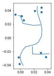
snkit has methods to:
- add endpoints to each edge
- connect nodes to nearest edges
- split edges at connecting points
- create node and edge ids, and add from_id and to_id to each edge
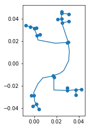
Spatial network
The output of a snkit data cleaning process might look something like this:
Nodes
| geometry | id | other attributes… |
|---|---|---|
POINT (0.03 0.04) |
node_0 | … |
POINT (0.03 0.03) |
node_1 | … |
POINT (0.02 0.03) |
node_2 | … |
Edges
| geometry | id | from_id | to_id | other attributes… |
|---|---|---|---|---|
LINESTRING (0.04 -0.04... |
edge_0 | node_10 | node_22 | … |
LINESTRING (0.01 -0.03... |
edge_1 | node_22 | node_21 | … |
LINESTRING (0.02 -0.02... |
edge_2 | node_21 | node_25 | … |
Development
Clone this repository:
git clone git@github.com:tomalrussell/snkit.git
Maybe set up a virtualenv or conda environment, as you wish. Then install snkit in editable
mode, with development packages:
pip install -e .[dev]
Run the tests:
python -m pytest tests/
Testimonials 💯 👍 😊
With five lines of snkit I replaced four or five hundred lines of custom code!
- Contented Customer (@czor847)