snkit
a spatial networks toolkit


/ˈsnɪkɪt/ – sounds like [snicket] (noun, Northern English) A narrow passage between houses; an alleyway. Alternatively, a python package to help clean spatial networks data.
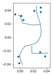
Say you have some edges and nodes (lines and points, connections and vertices). None of them are quite connected, and there’s no explicit data to define which node is at the end of which edge, or which edges are connected.
For example:
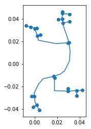
snkit has methods to:
add endpoints to each edge
connect nodes to nearest edges
split edges at connecting points
create node and edge ids, and add from_id and to_id to each edge
Spatial network
The output of a snkit data cleaning process might look something like this:
Nodes
geometry |
id |
other attributes… |
|---|---|---|
|
node_0 |
… |
|
node_1 |
… |
|
node_2 |
… |
Edges
geometry |
id |
from_id |
to_id |
other attributes… |
|---|---|---|---|---|
|
edge_0 |
node_10 |
node_22 |
… |
|
edge_1 |
node_22 |
node_21 |
… |
|
edge_2 |
node_21 |
node_25 |
… |
Testimonials 💯 👍 😊
With five lines of snkit I replaced four or five hundred lines of custom code!
A. Contented Customer (@czor847)
Acknowledgements
MIT License

Copyright (c) 2018 Tom Russell and snkit contributors
Initial snkit development was at the Environmental Change Institute, University of Oxford within the EPSRC sponsored MISTRAL programme, as part of the